
Grenoble and Mont Aiguille
/
View Le Mont Aiguille in a larger map
With the festival of la Toussaint (All Saints’ Day) falling on a Friday, it seemed like an opportune time to sneak in a late autumn hike. I had seen a picture at some point of a very distinctive peak in the Alps and bookmarked it as an overnight hike, with the only problem being that getting there and away was a bit of a pain from Paris, due to a lengthy changeover in Grenoble. So with a long weekend providing the buffer day, we headed to the central Alps to explore the crown jewel of le Parc naturel régional du Vercors, le Mont Aiguille (Needle mountain)
An ignoble city?
Mont Aiguille sits about six kilometres from the town of Clelles, which itself is fifty kilometres south of Grenoble, with a train servicing the single-line rail every two hours. To ensure we profited from being in the region, we took the time to look around the city of Grenoble, rather than just pass through. We both arrived on the eve of la Toussaint and stayed the night in town. We had organised to take the train to Clelles at 1609, so we had the bulk of the day to look around.
I hadn't heard much about Grenoble prior to going, mostly that it was industrial, dirty, student-oriented and not very interesting. The first thing one can say is that the surrounding area is really pretty. To the east are the Alps and to the north and south are the more escarpment-likes hills of Chartreuse and Vercors respectively. However, for our visit, it was quite overcast, so imagination was required. Unfortunately, due to the public holiday, we had a bit of trouble finding places which were open. In particular, getting breakfast was a bit of a mission. But in the process of trying to find something, we were wandering the backstreets of the town, which were surprisingly nice. The city had a lot more to it than I had been expecting, particularly around the town centre. We stumbled across a market and enjoyed a local nut-based delicacy, which was pretty darn tasty.
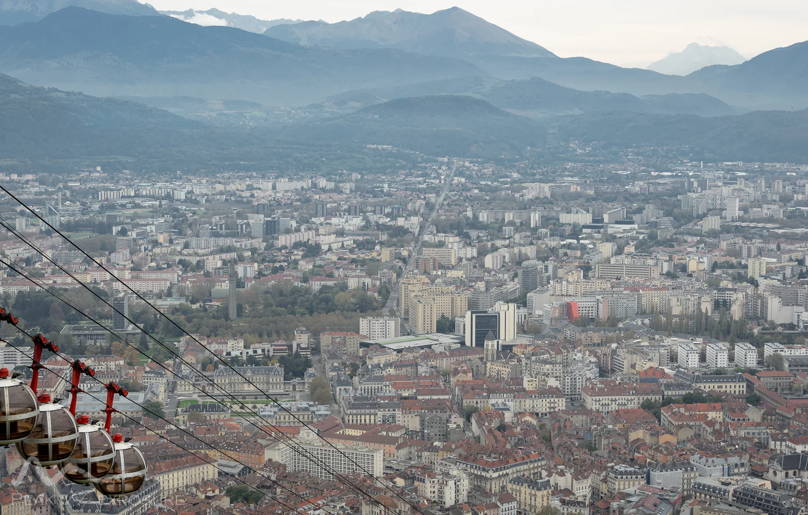
Grenoble from the Fort de la Bastille
We moved on to climb the dominant Fort de la Bastille, which overlooks the town as served as a fortress from the just before 17th century. The climb up is about 200 metres vertically, which winds through the surrounding park (Jardin des Dauphins) via many different paths in an erratic manner. But at least on the way up, it is pretty easy to know where you need to go. After 20 or so minutes, we arrived at the top of the fort, which is now a mountaineering museum. But in addition, one gets a rather nice view of the city; to the south we could see that it was a bit clearer, which was nice as we were hoping for good weather for our hike. After exploring the summit and visiting the near-by Mandrin caves, we had seen about all there was to see so headed back down. This was slightly more confusing than the ascent, due to the multitude of paths and the structure of the ramparts. But exploring the ramparts was not at all a negative, as they are – by design – very complicated and intricate.

The Collégiale Saint-André
By the time we were back in town, there was a little bit of blue sky around, that was appreciated when we visited the Collégiale Saint-André, with some really nice stained glass windows that were illuminating the incense that was aloft in the church. We stocked up on some lunch and dropped by the Paroisse Catholique Notre Dame de l'Espérance on our way to the station. The train ride to Clelles was only an hour, but it was quite interesting. The train goes though the industrial suburbs before heading into the mountains and gaining altitude. There were many tunnels and bridges which are always entertaining, but I was most pleased when a little boy was waiting at his fence for the train and was waving violently as we went past; the train driver blew the horn and he was clearly chuffed by this. There were also some notable stations, which were pretty close to private stations as there appeared to be no infrastructure and only single dwellings close by.
At about 1720, we arrived at Clelles-Mens, from where we had to walk to our accommodation. We were not bivouacking as the le Parc naturel régional du Vercors forbids it and there were no campgrounds nearby, however if I had my time over, I would bivouac. There was ample space and no-one around – which may have been a result of the season – and the scenery was great, which would have made for the perfect camping conditions. But alas, we had already organised accommodation at the cross country ski/hiking lodge of Au Gai Soleil du Mont-Aiguille in Richardière. Unfortunately the sun was setting and the overcast conditions meant there was not much light around, which made the walk perhaps less pleasant than it should have been. A decent chunk of it was also on a curvy mountain road with non-zero traffic, so we were never quite comfortable.

In and around town
We eventually made it to the lodge, had some pretty tasty food and then headed to bed after having packed our bags for le tour du Mont Aiguille.
Around we go

Le Mont Aiguille

Breaking through the clouds
We were up before the sunrise hoping to get a good start on the walk, mainly as we did not know how long it would take. The tour is about 20 kilometres and is relatively “flat”, in that no major peak is climbed, but there is still plenty of up and down. After having breakfast, we headed out into the rain and got our first view of the area with some light. Even though the mountains were in the clouds – most notably Mont Aiguille – we still got the impression that they were impressive. We headed to the east as we were making a counter-clockwise tour. The track is marked for the entire length, but in sections it was not well marked and our map (IGN 3236 OT) was definitely worth having. The track starts off by cutting though some paddocks and then in to some heavy forest. There was one section in particular which was difficult to navigate due to fallen trees, and the recently-fallen leaves meant that any track was covered up, so the right direction was not at all obvious. Combined with rubbish visibility thanks to the rain, we were off to a rough start.

The autumn colours were out and about

The small church in Trezzane
Le Mont Aiguille, as seen from the north
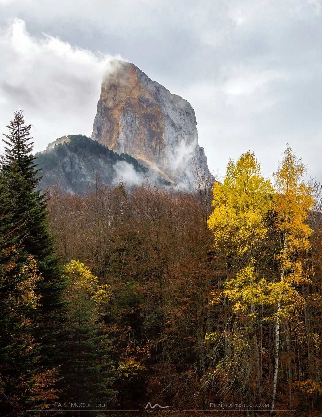
We came to a service road which led on to a paddock, and we were treated with our first views of the mountain – which is really something. As its name suggests, it really is a needle, well in one dimension at least, and with the late autumn colours, it made for a nice scene. One can only imagine what it would look like with nice weather! The service track turned off onto a small walking track which began to climb onto one of the surrounding ridges. We climbed up to the most prominent knoll, which had wooden guides for the eye labelling all nearby mountains, but unfortunately of the 10 or so which were labelled, we could see only one. So we continued on our way. After a while, the track descended a little and eventually met up with a road, which we followed into the village of Trezzane. Other than a few farm houses, there is not much there, apart from the little church with a beautifully thatched roof. So after we had a little look around, we set off on what would be on what would be one of the main climbs for the day. The road starts to switchback and head up to the Col de Papavet whilst the track takes the direct route up through the rocks. The section probably would not normally be too rough, however due to all the rain, the clay had become extremely challenging to walk on, particularly on the steeper terrain. It was thus unfortunate that there was a work crew taking a break at the Col and watching us struggling to climb the final and steepest part of the climb.

The cliff-side strata

During the climb to the cliffs
From here we knew we would not have too much more climbing to do as we were atop the ridge and near the highest point – other than the Mont itself. The landscape in this area was really interesting, as you could really see the strata, which was extremely colourful and sitting at about 45 degrees to the surrounding rocks. It was quite pretty! We continued on our way, now heading west on the north side of the mountain. We really started to see more of the mountains at this point, as the clouds were opening up. We also saw a man searching for his dog, which we had not seen, and then about 5 minutes later encountered said dog, which stuck with us for a bit before disappearing into the forest. When we arrived at Col de Pellasa few minutes later, we encountered someone else who looked like he would also be looking for the dog, so I told him where we had seen it and then he ran off in that direction blowing his horn, so I guess he was searching for it after all. From here we started to descend into the valley towards Les Pellas, where the weather was looking really quite nice. We came past a paddock which was super lush and green and also had an amazing view of the surrounds, so we stopped here for a few minutes, but as we were near Les Pellas, we decided to push on and find somewhere down there to have lunch.

The valley of Les Pellas
Arriving, we saw there was little other than a few farm houses, so instead of heading in to the village we stayed on the track and hoped to find a suitable place – which basically meant a dry place – for lunch. A kilometre along the track we came to Parcours aventure, a ropes course and rock climbing school. One thing I have yet to mention is why we were doing a tour rather than summiting Mont Aiguille. The reason is simple, being that you cannot climb it without a decent level of climbing ability as it is a sheer cliff the entire way around with minimum height of 150 metres; hence the nearby climbing school.

The peak is really a pretty solid climb!
Once it became apparent that we were not going to find anywhere to have lunch comfortably, we found a stack of logs which were not too wet and smashed some food. The rain had disappeared, but the temperature had begun to drop as a result. We did not rest too long before we were on our way, and we were then heading south on the western side of the peak. As we had lost altitude heading into the valley, we had to pick it back up; but what the map did not quite show was that we were actually climbing up to the base of the cliffs, so we gaining much more altitude than anticipated, not that this was a problem though! During the climb, we came across some waterfalls (la cascade de la pisse), and in a bid to get a good look at them, we went off-road. This turned out to be an interesting manoeuvre, as the terrain was pretty brutal. It took us a good bit of time to climb up – to a spot where we could not see the cascade, only hear it – and then we were forced to climb up some seriously rough terrain to get back on track. However, on track is not quite right, and as the path seemingly disappeared, we just followed the creek until we found something consistent with the map – which never actually came! I never like flying blind, but for a while we really were. We were on a well-worn track which had numerous rogaining markers along it, but it was not at all what the map said. When we finally hit a clearing where the trail made a switchback, this was the first point that agreed with the map and subsequently my GPS position on my phone, so we had made it to the right spot, just what the map said would happen and what happened were not the same thing. But from this rather exposed clearing, it was only a short walk to the base of the cliffs, so we ditched our bags behind a rock and went to have a wander around it. The weather had finally cleared enough to get a view of the surrounding area, both Vercors and the Alps, of which I am tempted to say Vercors looked the more interesting. It was much more alien, for lack of a better adjective – a lot of uncommon colours and formations. But the wind was pretty brutal and the imminent setting of the sun made our stay up the top fairly brief. We came down from the cliffs, picked up our gear and headed to the nearby Col de l’Aupet.

Looking back at Les Vercors
From Col de l’Aupet, the descent was steep, muddy in sections and encased in dense forest. The drop in height is about 700 metres in approximately 2 kilometres, so you are aware that you are going down, but it is not long enough to cause any problems. As the sun was setting, we arrived back at the lodge, cleaned up and enjoyed a tasty meal – including the local specialities of tiny ravioli and also fromage blanc. I am not sure how the latter is a speciality, as I had always thought it was from northern France/Belgium. But the lady insisted that it was a local speciality; perhaps it was made by them. In any case, it was delicious. Tuckered out after a good hike and a good dinner, we headed off to bed.

A view towards The Alps, with Clelles in the foreground
Just (Chi)chilianne
With a somewhat more relaxed morning, we got organised for our departure after a leisurely breakfast and headed out into the much nicer weather. There were still plenty of clouds around, but there were also patches of blue sky; no rain was also a big bonus. The cloud cover that was around was also above the surrounding mountains, so it was not so oppressing. Our task for the day was essentially to get home, and not much else. The only trains which depart Clelles during the day on a Sunday are at 0842 and 1443, and with trains leaving Grenoble at 1800, we preferred the latter. Had we been camping, this would have been better since one could time their walk to coincide with the train. Even still, we took the opportunity to walk along the ridge heading south-east to the town of Chichilianne. The walk was quite nice – if a little muddy – with some absolutely massive boulders than one can only assume came from the nearby mountains, but given their placement, it would have been an impressive and highly improbable trajectory required to end up where they have. However I can offer no better explanation.

The view from Chichilianne
In an hour or so, we arrived in town, which was the largest that we had encountered in the region, but that is not really saying much. There was a nice little church and a semi-castle-cum-hotel in the area but that was about it, so we didn’t stay all that long. However this left us with not much else to do before our train, so we slowly ambled back toward Clelles. Near to the station, we decided to turn off and visit the very impressive viaduct (le viaduc de d'Orbannes) that we had crossed a few days earlier on the train. As structures like this are a dime a dozen in this part of the word, it is easy to forget just how impressive they are. The detour is about 20-30 minutes each way from the station, and has a pretty deep drop down into the valley, but the bridge is really quite spectacular. After spending enough time here for the weather to deteriorate, we headed to the station to hold out for the train.

The first completely clear view that we had!
When it arrived, we were unpleasantly surprised to find an overfull train. With so few services and a long weekend, it makes sense that people were returning to the cities. It was just unfortunate to be standing in a rather narrow carriage surrounded by people’s baggage on a mountain railway – which are not exactly known for their long straight sections. But sure enough an hour later we were in Grenoble and this time, we had a nice view of the surrounding Alps, particularly as the sun began to set and illuminated many of the anomalous rock formations which encircle the region. I was interested to read that geologically, well before the rise of the Alps, that area (which is essentially the lower section of the Jura) was much like the archipelagos of Bahamas today, as evidenced by said rock formations – which are, as one would expect, extremely rich in fossils. But as the sun set and marked the end of the day, so too did it mark the end of our weekend. We boarded our trains and headed back to the everyday and left what would be the last of our 2013 autumn adventuring behind.

Le viaduc de d'Orbannes