
Zermatt
/
View Zermatt in a larger map
Before I moved to Europe, there were only a few places on my list of “must see” places. Whilst we had visited some amazing places, including one place off this list (Norway in the winter), one of the most iconic destinations I wanted to see was the town of Zermatt, or more accurately, Mont Cervin - also known as the Matterhorn. The Feast of the Ascension of Our Lord and Savior Jesus Christ was the third holiday to fall on a Thursday in May, and again, il a fallu que je fasse le pont. So only three days after returning from Switzerland, I was heading back to Geneva on Wednesday night and then into the deep Pennine Alps for some spring hiking.
Planning
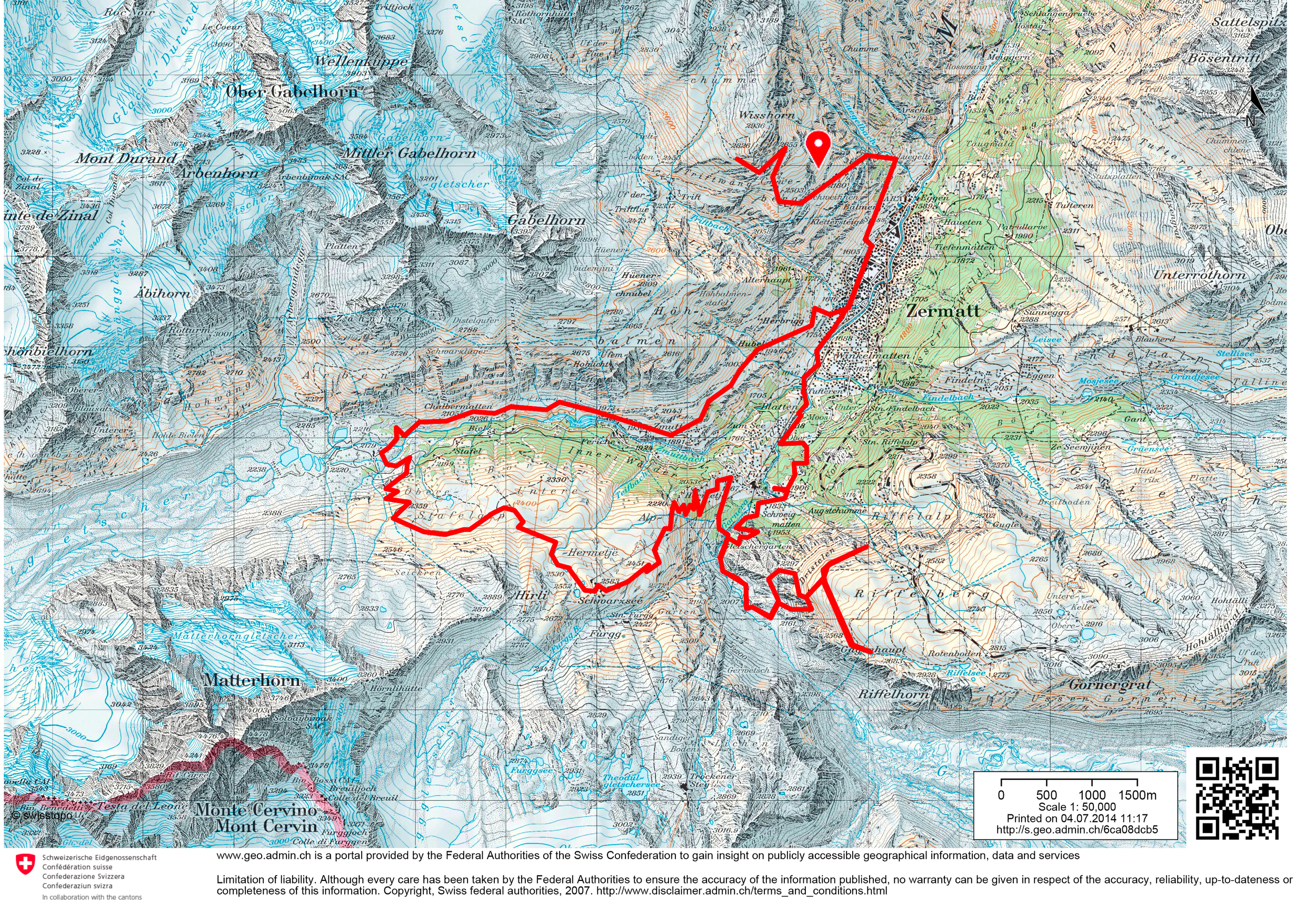
The hiking route
Finding information about the appropriate time to go hiking in this area was quite difficult. Most sites say something along the lines of “the best hiking is in the mid-to-late summer” or “a great skiing area in winter” and nothing in between. So if you are seeking information about “hiking around the Matterhorn in May” I can definitively say it is too early. I will elaborate on why this is later, but ultimately there is too much melting snow which makes the going tough. Planning a route, on the other hand, is very easy; we used the Swisstopo 1348 (Zermatt) 1:25 000 to cook up a nice walk. I always hike with a map, but if that is not your thing, you can access (and download!) all the map data online- which is simply fantastic - and plan your route.
Just a warm up
In Switzerland, it is less acceptable to make long weekends, so as a variant of this, Mia would work on the public holiday (Thursday) and take the Friday off, so at least it would be a three day weekend. This meant that I was on my own for Thursday and I would have the constraint of meeting Mia at the train station in the evening, so I had to find a suitable mini-trek. I considered going to a different location entirely, but in the end it was just easier to do something in that area. I set out early on Thursday morning for the near-four hour journey to Zermatt, which leaves every thirty minutes, with a single change in Visp. The journey to Visp was really starting to feel routine from our other trips to the area (LINK) but it would be the first time we would take the “glacier express”, Switzerland’s much touted wonder railway. Other than a few near-complete glass carriages, the only other point of note about the train is how uncomfortable the seats are. As the Zermatt area is so iconic, the train is loaded with people fresh off the plane heading for a week at a mountain resort and is one of the only places in Switzerland that as a hiker you look out of place!
The narrow-gauge dual conventional and funicular train winds its way up the very impressive valley, passing some stunning canyons and stopping at some picturesque villages, but almost everybody is on their way to Zermatt. One of my first goals on arrival was to scope out the campground just north of the train station, at which we were planning to stay. Unfortunately for us, it was just a concrete slab with some snow and fake grass on it which said something along the lines of “open in summer”. I had noticed that there was a campground at Täsch, the stop before Zermatt, so this would become the new target; however this left me in Zermatt with about 7 hours of sunlight. After studying the map, I decided I would attempt to climb the Wisshorn, which is roughly 1500 metres above Zermatt and only 1500 metres in a straight line from the station.

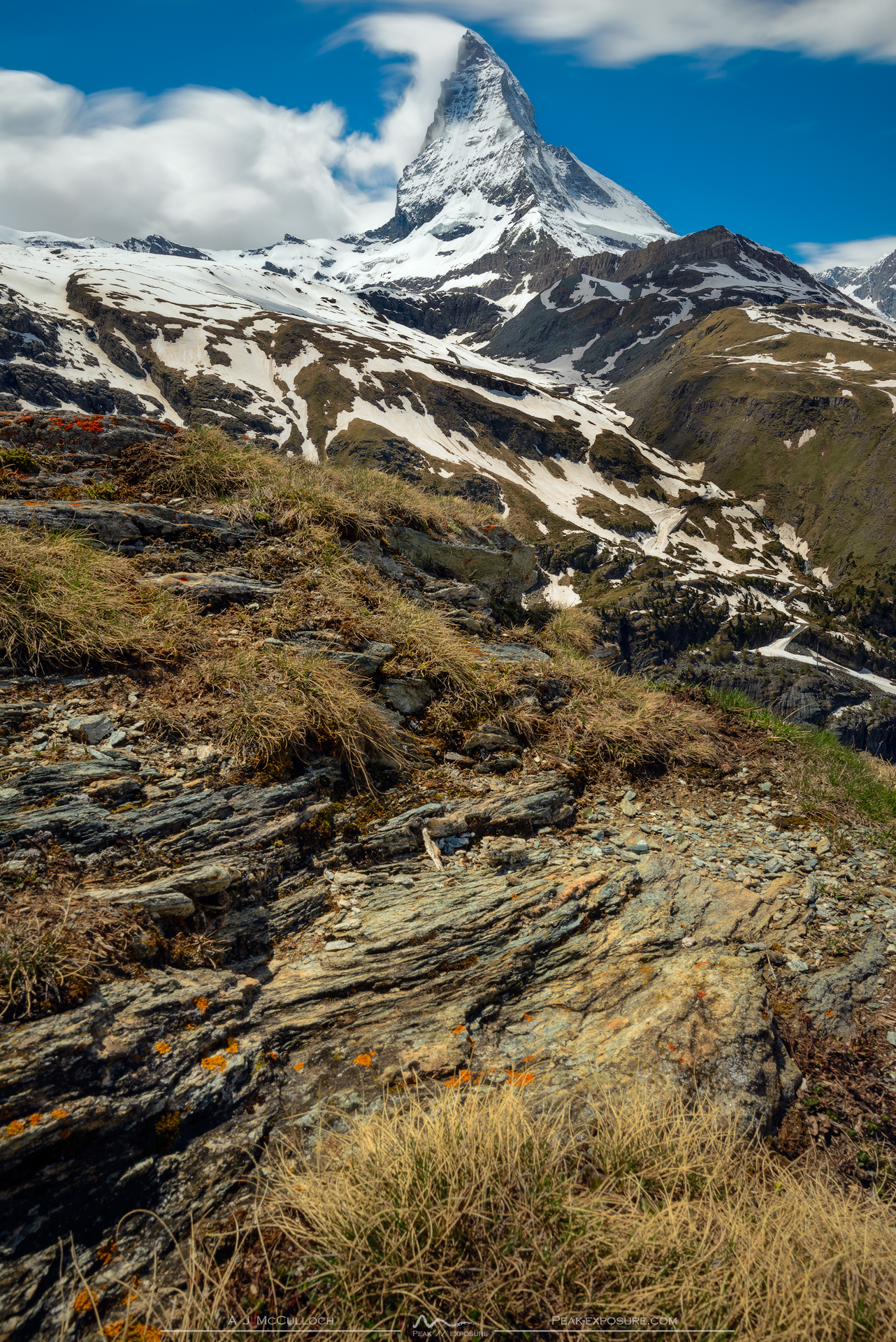
The first view of the Matterhorn
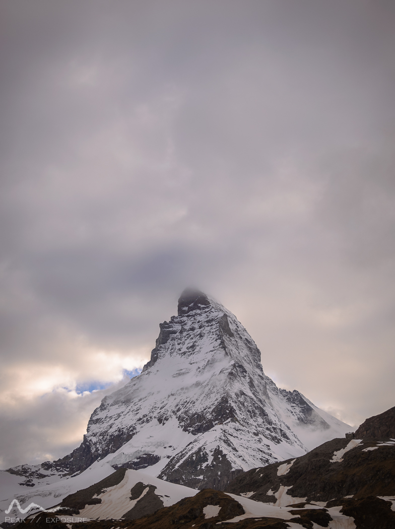
Directly behind the station is the Bahnweg which runs between Zermatt and Täsch, and after some hundreds of metres the track splits into either the gentle river stroll or the brutal uphill of the Wisshornweg. As this was the first big hiking trip since before the winter, it was really nice to get out and about - especially as there was not one other person to be seen for kilometres around - outside of a resort that is! The track quality was great, albeit extremely steep in sections, but I was going at a good pace to reach the summit (or so I thought). As I ascended further and more importantly headed south, what was hidden during my brief time in Zermatt eventually was shown to me in full glory: the Matterhorn. There is not much I can say that has not been said, but the mountain is truly impressive. It towers above everything around and is unquestionably aggressive in doing so. The regular afternoon banner cloud was forming and looking majestic in doing so, and I ended up sitting down and just admiring the view - and of course taking some photos. Once I had decided it was time to move on from my comfortable spot, the track somehow became even steeper and started winding through avalanche barriers, which really impeded my progress, particularly as the track was extremely muddy. After a while of climbing, it became apparent I was not going to be able to reach the summit, get back down and catch the train to Täsch with any light, so some 200 metres from the top, I turned on my heels and descended by the same route that I had climbed.
Trains between the two towns are regular and run every 20 minutes, taking only 12 minutes and costing 4.10CHF. I arrived some 10 minutes before Mia was scheduled to arrive from Visp, so I wandered over to the campground which was not staffed but had a few other campers. I found information about tariffs, but not much else so I just picked a nice spot and set up camp. Mia arrived not long after, so we had some dinner and got an early night in preparation for the big couple of days to come.

Clouds forming over the Matterhorn
Marmots
We awoke early to a very icy morning with some average looking weather on the horizon. We packed away our site and headed over to the office to settle up. We had seen that the prices were 7 CHF per tent, which is pretty reasonable, but it turned out that camping prices were 8 CHF/person, 7 CHF/tent with a 2.50 CHF/person visitor tax and a 1.50 CHF rubbish tax, which finished up at a little more than 30 CHF! We handed over our money and made our way to the station to take the train back up to Zermatt. This would have been uneventful were it not for the man on duty. The ticketing/gating system is automated, but as we were the only people taking the train, when we scanned through he started demanding something from me, I just did not know what it was. Once it was clear we did not speak German he switched to English, but was essentially just repeating the same phrase over and over. Unfortunately, the phase, which he clearly thought was the same in both German and English was halbtax. In retrospect it is clear that he wanted to check our SBB half-price cards, but at the time it was simply a mess. We eventually figured it out - he was visibly surprised that we had the cards, as he apparently thought we were just trying to scam the system.
Arriving in Zermatt, we made a beeline to the other side of the town where the trail began. The town of Zermatt is a strange place. It is filled with the tacky things that one has come to expect when visiting a famous landmark, but even this does little to sully the general magic feeling of the town. Walking along the Bahnhofstraße, one eventually arrives at the very pretty Triftbach, a small river running through the town, which also marks the point where one turns out of the city and starts to climb up into the fields. As soon as you leave the town, any land that is not rising ferociously is covered with lush grass and wildflowers, just as I had been led to believe.

Chalbermatten
The trail climbs steeply and winds to Herbrigg and then Hübel, which would be a fantastic spot to camp, with a large flat lush ground as well as a small hut. The trail then slowly descends to the valley over the Zmuttbach and eventually arrives at Zmutt, a small collection of houses and restaurants, along with the end of the valley road. As a consequence, it is also where the bulk of the people visiting Zermatt (if they are feeling adventurous) turn around. Once we passed though, things became much quieter and started to feel a little more remote. One of the direct consequences of the reduced number of people - in fact, we saw no other people from that point on - was the dramatic increase in the number of marmots.
Having spent a fair bit of time in both the Alps and the Pyrénées, I was no stranger to marmots, but I had never seen such a quantity; every corner we rounded encountered another labour of marmots (labour is the collective noun for moles, and from what I can tell, there is no specific collective noun for marmots, or groundhogs for that matter, however someone has cleverly suggested a repetition for the latter). On a few occasions we were able to watch some pretty hearty scraps between males which were as cute as they were terrifying.

The Matterhorn
The path continued up the valley and we were increasingly pressed into the cliffs of the Ober Gabelhorn towering over us. The weather had not been bad, but nor had it been great; there was a lot of cloud around and we had not been granted a view of the surrounding mountains. As we came into Chalbermatten our fortunes changed and we were granted a few minutes to admire the Matterhorn, which was towering some 2300 metres above us at that point.
Sunset, with the clouds settling in for the night
The cloud returned and we pushed on the flattening terrain as we we approached the glacial snout, which is also home to a large quarry. As we made our way down to the river, the path diverted from its usual course due to a massive landslide, which added an extra kilometre or so, as we had to zig-zag our way down below the landslide and then back up to the path. After the detour, we were at the top of the river; surrounded by boulders we decided that it was a nice spot to sit down and enjoy some lunch.
The path we had chosen then began to ascend on the northern side of the Matterhorn, the slopes of which above Zermatt are used for skiing. This meant that there were access roads mixed amongst the walking tracks, both of which were starting to be covered with snow and were becoming increasingly difficult to discern. We had no final destination per se, but rather we were heading up Hirli and looking for a nice place to set up camp. I had my eye on somewhere near the Schroarzsee, in the hope that if the wind died down there might be some reflections of the Matterhorn to be had. The path up was brutally steep to begin with, climbing some 400 metres in approximately 800 metres, but then followed the contour of the landscape until the last push up to the summit. Coming up on the lakes it became readily apparent that we would not be seeing any reflections in them, as they were still frozen solid! We found a small one that was starting to thaw and was stuffed to the brim with tadpoles - well, almost frogs really - which was also pretty neat. We passed by the small church (of course there is a church up there!) and found a nice area to set up the tent which had a great view over Zermatt to the north and the Matterhorn to the south.
As the sun started to go down, the weather started to calm and during our dinner we were once again gifted a view of the Matterhorn, with some pretty spectacular cloud encasing the peak. As we were at 2600 metres, as soon as the sun was down the temperature dropped like a rock and it quickly became time to go to bed; I would wake up at 0200 in an attempt to photography the Matterhorn under the stars, but be greeted with dense cloud and gale force winds.

Not a bad spot to camp
Down and up and down again

Sunrise over the Zermatt valley
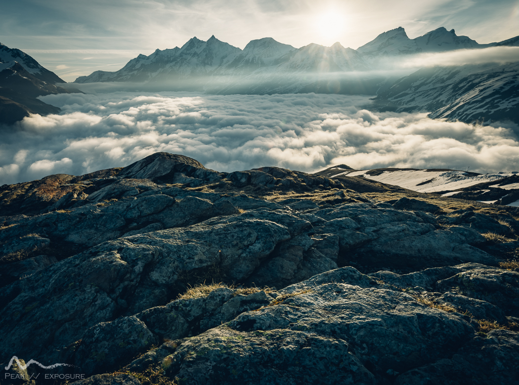
Waking up before the sunrise is always risky business, especially as the weather during the night was rather wild, however in this case it paid off. There was not a cloud in the sky above, but the valley below was filled with an ocean of cloud. The first rays of light were illuminating the Matterhorn which was a really special sight. I sat around absorbing the sunrise and the landscape, reflecting on not only how lucky I was to be doing so, but also how nice it was that there was nobody else around.

The Schroarzsee, nice and frozen
We packed up and set out on our way, knowing that we had a lot of height to lose and then more-or-less the same amount to gain again. Heading down the spur which runs parallel to the Furggbach, there was a fairly poorly formed path. As large sections were still under snow and those which were not were mud pits, sticking to the trail was not entirely trivial. For quite a while we were just following the spur until we spotted a creek running through the path, which eventually turned off down a gully to leave a pretty decent path, which provided much more comfortable walking than bashing through alpine shrubs.
Lichen Bretter
The path starts to deeply descend as the trees return, and then winds down through a pine forest on the way to Hermetje, a collection of three buildings in the middle of nowhere. At this point there are paths leading every-which-way and a detailed map is indispensable. The trail continued winding down through the woods until we popped out amongst some properties near Furi, which seemed to be a cable car exchange. Thankfully for our knees, this marked the bottom of the descent.

La dent blanche
Our next stop was the Gletschergaten, which one reaches by passing through some alpine meadows before crossing the Furggbach in spectacular style: a 100 metre long suspension bridge traversing the gorge 90 metres above the river. It was easily the most impressive bridge I have crossed whilst hiking and is definitely not for anyone with a fear of heights. After crossing it is not far to the Gletschergaten which in effect is just a playground, but it does also serve as an intersection for a number of trails.

Wandfluehorn
Our plan was to get to the Riffelsee, where one gets the postcard image of the Matterhorn reflected in a tarn, meaning that we were climbing back up to a similar height from which we had just descended. The most direct path followed the Gornerbach, a filthy river full of sediment which flows from the mammoth glacier at the base of the towering 4600 metre peak of Punta Genfetti. There were a few people on this trail as it is accessible via cable car, but the trail to climb up to the Riffelberg separates from the glacier path after two kilometres or so. Arriving at the intersection it is a little hard to imagine that there is a track that ascends the Riffelberg as it is just cliffs. Surprisingly, there are two paths which go up, with one being ever so slightly steeper than the other; the steepest path gains 450 metres of elevation in a little under 500 metres. We started up the steeper of the paths at the same time as another group started up the other path.
Clouds starting to rise out of the valley
The climb was tough but it was over fairly quickly; there was very little snow, although it was a little damp in parts due to a rather tall waterfall dumping water onto the track. At the top of the track, we saw the paths rejoin not far from a fantastic rock where we would sit to have lunch and admire the view of the entire Zermatt region. It was a bit of a late lunch, but as the lake was only a few kilometres past, we were happy to have a late lunch and a cruisy afternoon stroll to the lake.

Gerroetsch
The afternoon clouds were rolling in
Once we were all finished up we made tracks for the Gagenhorn, which sits in front of the Riffelsee which is itself in the shadow of the Riffelhorn. In a very short distance with almost no elevation gain, the very patchy snow became a solid ground-cover. Usually this would not be such a problem, but being a sunny spring day, everything was very soft so it was a real slog to go even very short distances. Determined to press on, we continued up the spur as the track and markers were well buried at this point; however, it soon became obvious that the going was just too slow and whilst we might be able to reach the lake, getting back to the train on time the following day would be near impossible. Additionally, the lake would certainly still be frozen and covered in snow, making it a much less interesting destination. As sad as it was, we decided backtrack along the path we had made to where we had eaten lunch and follow another path around the Riffelalp, which was in the opposite direction.
What we hadn’t planned on is how much snow would also be on this path. Whilst we were losing altitude, it was now on the north face and the path traversed some deep gullies, meaning there was lots of snow bridges of varying thickness which were all softening up. The going here made our previous walk on the plateau seem positively pleasant. In all honesty, the traverse was dangerous and we should have not done it. There were numerous incidents when the snow caves below would give way, tearing my legs to shreds and presenting an opportunity for me to lose balance and slide down the snow and off a cliff edge. We told ourselves that once we around the next ridge that it would get better, but after 6 or 7 crossings we rounded the final ridge which revealed the entirety of the north face, all of which had the same conditions. We had no choice but to backtrack once again and drop down into the valley the way we had come up. This was soul crushing as we once again had to backtrack, but also as the crossings were pretty dicey and we had to traverse them all once again - which required both care and a lot of time.
We once again arrived back at the point at which we had lunch and prepared ourselves for the descent. We decided that we would take the other path down for at some variety. Upon reflection, we should have deduced that since we did not see the other people whom we saw starting the path that we were about to attempt, perhaps it was not wise to proceed. But this is not what we thought; we just wanted to get down. We were tired, it was getting late and my legs were a mess. We began the descent and before to long, the path disappeared into the snow and the shrub got much thicker. Unlike the path we took up, which was steep with lots of loose rock, this path consisted of large boulders which had to be navigated over. Usually this would be fun, but combined with the snow, the lack of a clear trail and the afternoon’s events, I was not having a good time. Half an hour into the descent we had not gotten far and I just wanted to turn around and go back and then down the way we had come up. Mia held strong and said just keep going, which turned out to be a good call as the path did improve not long after I had lost faith in my ability to navigate down. Once the track opened up and we could see the Gornerbach, our spirits lifted somewhat, but we were both pretty defeated.

Hello Alps!
We wandered in the general direction of Furi, knowing well that all around where we were would not be a nice place to set up camp. We were simply following a track down form the Gletschergaten and looking for anywhere to set up camp. Complicating matters was the fact that all of the land in this area is privately owned (farmland mainly) so we did not want to just set up in a paddock in plain sight. We found a great area just outside a pine forest; however upon closer inspection it was effectively a marsh, and another blow to us as from a distance it was perfect. Not too far past this, we were passing by Furi and noticed some rocks jutting up between two properties (not far from Restaurant Alm Zermatt), creating a fairly large shielded hollow near the Gornera. It was picturesque and had some of the softest, lushest grass I have ever seen. Without hesitation, we cut across some paddocks, set up for the night, made dinner - including an instant chocolate pudding which Mia had brought along, which did wonders for our spirits - and then we collapsed into bed.
Kebap training

Inside the Gornerschlucht

The canyon was impressively deep
We awoke to a beautiful morning, and due to our camping location we packed up pretty rapidly. Our overall plan was to get back to Zermatt, on to Visp and then back home. The walk was a pretty simple stroll down the hill, but upon looking at our map, we notice that there was a path that wandered along the Gornera, in what appeared to be a deep canyon. Of course we designed our path to take us via this route, so we ventured off through into the forest.
As it would turn out, the Gornerschlucht is a tourist attraction with an admission fee (4.50CHF) so it is surprising that it was not signed at any of the many path intersections. Obviously as one gets closer to the town, the number of accessible walks dramatically increases so we were pretty happy to have a map. Before long we had arrived at the southern entrance to the gorge, where one is greeted by a steep descent into the canyon via a ladder. There was a sign saying access to the canyon was by admission, but there was no way to pay, so we just headed in.

The view walking back into town
The canyon was unexpectedly fantastic. There is obviously a lot of water coming down from the glaciers, and this Gornera has been working very hard to get through as much granite as it can. It was not quite a slot canyon, but it was impossibly narrow at a few points with an incredible amount of water rushing through. The path was an excellently maintained boardwalk which hovered above the canyon, only a few metres above at some points and some 50 metres at other points. The rock formations were exquisite and the forest lush, making it a highly enjoyable experience. Upon exiting on the northern (lower) side, a woman waited in a small isolated booth to collect our money and probably hoped that we would pick up an overpriced ice cream or postcard, but it was not her lucky day. From this point, the walking path resembled a road much more than a track, and over the next hundreds of metres its metamorphosis would be complete; however just as the tarmac would take over, we were treated to the postcard view of the Matterhorn: a field of wildflowers with some wooden huts in the midground. It was a really nice way to finish up our trip, as from this point on, it was into the town, where tourists with massive suitcases filled the streets, buying overpriced Toblerone chocolate bars to use in forced perspective photos and enjoying criminally expensive hot chocolates. It goes without saying that we were terribly jealous as we nibbled on our studentenfutter.
I had a train to catch from Geneva in the evening, but we were a little ahead of schedule, so we figured we would take the first train out of Zermatt and take a look around Visp before heading to Geneva. Unwittingly, we would start what would become our post-hike tradition, namely getting a döner kebab. The train ride down the hill was fantastic, simply as the scenery is as good as it gets, and we would also find inspiration for another hiking trip in a brochure (see later!). Once we were in Visp, it was a Sunday afternoon so everything was pretty sleepy. We made our way to the town centre and found a great looking kebab shop at the Kaufplatz. I ordered in my broken German and Mia followed up with some even more broken German. Needless to say our communication was not lossless, so whilst I received what I wanted, Mia got something slightly different. In any case, it was delicious.
After a brief look around, we were back on the train to Geneva, where I stocked up with some baked goods for dinner and got on my train back to Paris. In an unexpected twist, I had actually gotten a 1st class ticket, which involved a free meal, that was actually really tasty. Otherwise, it was the routine trip home, from where I would again depart in a few days thanks to the Pentecost long weekend...