
Bernese Oberland
/With perhaps one exception, the Matterhorn, the Bernese Oberland is the pilgrimage in Switzerland for hikers and climbers alike. Despite me being woefully sick and the weather quite uncooperative, we were able to explore Interlaken before heading up to Grindelwald. From here, we were the only ones continuing on into the hills, with sporadic rain and snow making things a little unpleasant. We gained altitude and then continued over the next day on what is oft touted as one of the world's best walks: below the north face of the Eiger. Given how low the cloud was, we could have been anywhere. We continued up to Jungfraujoch which was above the clouds, and over the next few hours the weather broke and we were treated to a pretty spectacular sunset. With some perfect weather, we trekked down into Lauterbrunnen, which offers unbelievable views of the surrounding highland as well as soaring waterfalls.
Be prepared
It begins with an email: Découvrez la Suisse à partir de 39€. The fact that it is May and most of my weekends are already full and I have trips to both Iceland and the U.S.A. lined up, no that is no problem. I arrive back from New York on the 11th of August and I have a friend’s wedding on the 23rd, but wait, what is this? L’assomption de Marie (Assumption Day)? Which happens to fall on a Friday? I cannot condone the archaic practice of dolling out public holidays for religious events - I would much rather we celebrated things that are worthwhile celebrating - but a public holiday is a public holiday. So lock it in: Paris to Interlaken for 39€, I will figure out the details later.
The plan is simple: meet on Thursday night in Interlaken, catch the train up to Grindelwald on Friday morning and spend the weekend walking to Lauterbrunnen before returning to Paris on Sunday night. Being Europe, and in this case, being Switzerland, this could not be easier. The area is well known for its stunning valleys and soaring peaks; the north face of the Eiger is a pilgrimage for all with even a passing interest in mountains. I had seen many websites touting one of the “world’s best day hikes” as the route between Eigerletscher and Alpiglen and we figured that a hike involving that would probably pan out well. Beyond that, we simply connected the dots between the train stations in the adjacent valleys and we had our Bernese Oberland adventure.

Brienzersee, Interlaken

Grindelwald
The reality of travel is that it can be draining. It is an immensely privileged and first-world problem to deal with, but that does not make it any less of a problem. A month of non-stop travelling for both work and pleasure had rendered me exhausted and consequently, susceptible to illness - which definitely was not aided by an intercontinental flight. The result of all this was me feeling terrible, and it did not aid in making the roughly five and a half hour trip from Paris to Interlaken enjoyable. I arrived just before midnight, but thankfully Mia - coming from Geneva - had already arrived, checked in to our accommodation (a “budget hotel”) and had been to a pharmacy to stock up on throat lozenges. Arriving anywhere in Switzerland is a treat, and Interlaken is no exception. Even though it was dark and cloudy, we could still make out the impossibly imposing mountains surrounding the town, and feel the power of the crystal-clear alpine torrent of the Aare is it cuts through the town. I don’t remember much of the hotel, I suspect I walked through the door and was fast asleep within minutes.
Wanderland

Berner Oberland-Bahn
The new day did not bring about good weather, but it did bring a pretty tasty breakfast. We were slated to take a late morning train to Grindelwald allowing us to have a look around town before setting out on the hike. Interlaken itself is a small town, with some 20,000 inhabitants and geographically confined in a valley sandwiched between the lakes Thun and Brienz. The surrounds are spectacular, but I would not go out of my way to visit the sights of the town. It is a good representation of a Swiss town, clean, ordered and a bit sleepy. The only stop on our list of things to see was the Brienzersee, which was some two kilometres from our hotel. The weather was pretty miserable, so I am not sure I took in much of the town from the inside of my hood. We were treated to a brief respite in the rain while at the lake’s edge, but brief it was. From here we made our way to Interlaken Ost, the main station and the departure point for the mountain railways. The journey to Grindelwald is via Berner Oberland-Bahn, a rack-assisted railway which took about 30 minutes and cost 5 CHF. As is often the case, the train was packed out with foreign tourists with ridiculous suitcases, and hikers and climbers were relegated to any spare nook and cranny with their “minimal” amounts of gear.
Arriving in Grindelwald, I was once again reminded of the scale of Alps: the sheer scale of the peaks here is something to behold. The town is at an altitude of roughly 1,000 metres, but the mountains which surround the town rise to 4,000 metres in a truly brutal manner. Unfortunately, to reach the hiking trail there was about two kilometres of road walking, out of town and down to the Schwarze Lütschine river. There is a bus that runs between the station and the trail head - and much further - but for two kilometres, quite frankly, that seems nuts.

The canyon formed by the Weisse Lütschine

Grindelwald, off in the distance
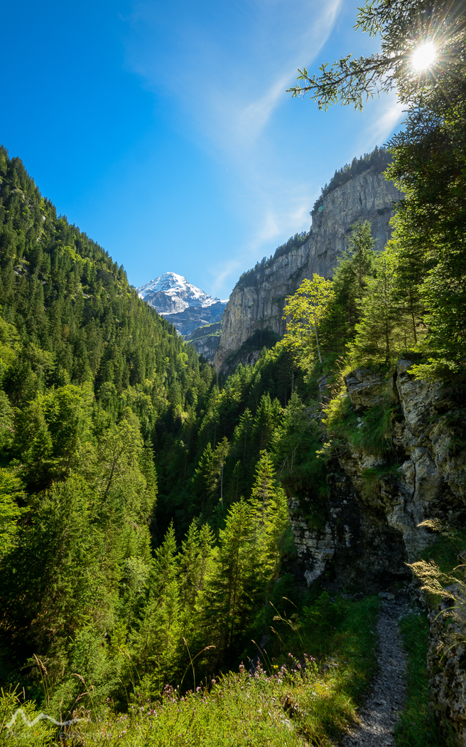
The trail begins with a gentle stroll through the pine forest at the base of the Mättenberg, which is delightfully pleasant. We came across an old marble quarry which provided some excellent seating for lunch, which was dutifully enjoyed. Before long, there is a crossing over the other half of the Lütschine river, namely the Weisse Lütschine (despite being a very murky brown). I can only assume that it is so named as it is fed by a vast complex of glaciers hidden away in the valley between the Eiger and Mättenberg. It is at this point that there is a period of both severe and inevitable altitude accumulation: about 500 metres of altitude in 2 kilometres, climbing what is essentially the north-eastern spur of the Eiger. Still the walk is through thick forest but one is regularly treated to views of the deep canyon eroded out by the Weisse Lütschine.

Mättenberg

Wild weather
Our walk had been going well and would continue to do so, despite the weather having other ideas. We were experiencing intermittent rain, although nothing too heavy, but that started to change, with more sustained driving rain and winds. The trail steadily climbed, albeit with much less gusto but to the point where the trees receded, the rain turned to snow and creek crossings gave way to snow-drift crossings. We had no final destination in mind, but rather were just looking for a suitable place to set up camp. There was certainly no shortage of water (something that still remains foreign for someone from Australia) but land that was sheltered, soft and flat was more elusive. We did eventually come to a hut (46.599899, 8.023249), in which we dearly hoped that we might be able to escape the weather and cook our dinner, but it was locked. Not far past the hut was a decent camping spot, so we set up for the evening. We hydrated our dinner and enjoyed every last bit of it before drifting off to sleep to the sound of snow settling on the tent and in the distance, raging rivers of water careening down the hillside.

The north face of the Eiger
Moo

No shortage of water
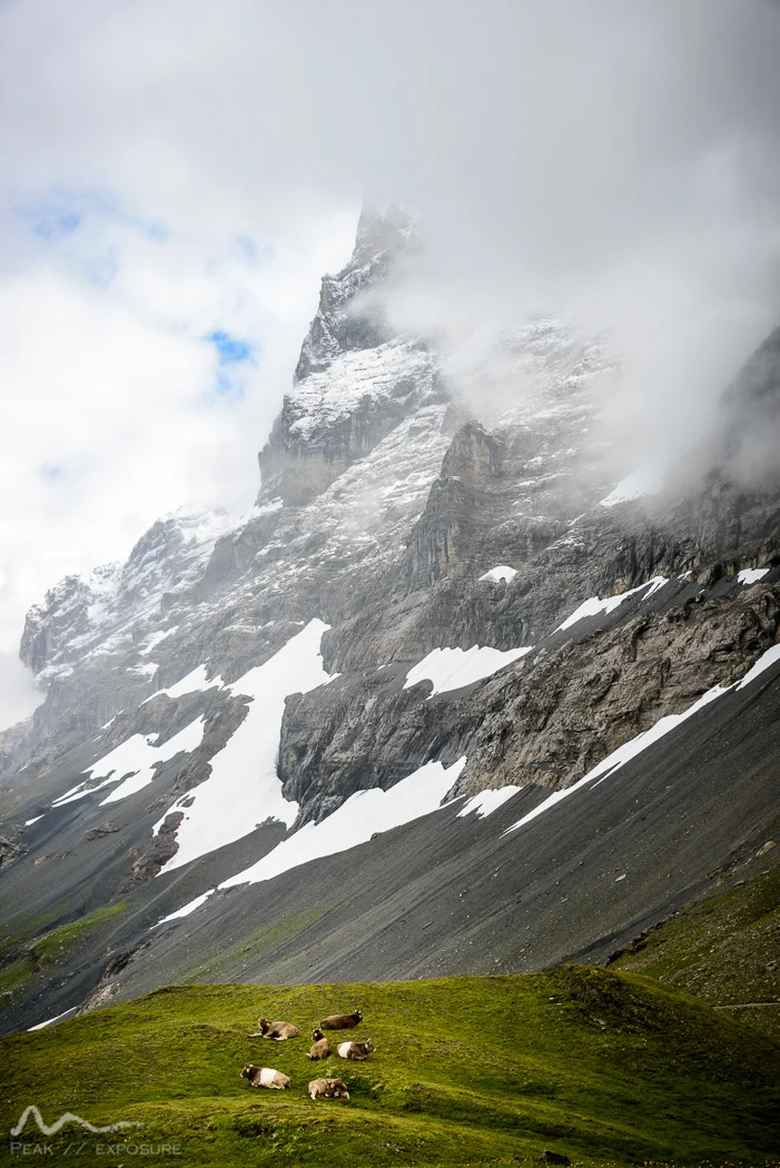
The night was windy, but thankfully did not bring too much precipitation. The heaviest of the bad weather had passed; however the clouds had well and truly set in, so our view was mostly white. Throughout the morning, the clouds lifted, but only some hundreds of metres, meaning we had sporadic views of the surrounding cliffs, but only rare glimpses of higher peaks and ridges. The path wended its way along towards the north face of the Eiger; at some point we hit the intersection of the track we were on and the path down to Alpiglen which meant that we were officially on the Eigergletscher Trail. In reality, the only thing that changed was the number of people. We went from seeing nobody else to seeing a few people. The people we did see tended to look underprepared, the mindset of “it is just a day walk” clearly evident; however I suspect the rough weather kept many people in the warm and dry of their accommodation.

Eigergletscher

Looking north, into civilisation and out of the Alps
The path had a few exposed sections producing a fairly sketchy scramble up a slab, made more hazardous by the moisture. The ‘local’ scenery (by which I mean that directly around the path) was gorgeous with exposed slopes, deep gullies and gorges and impossibly green grass wherever it could grow, complete with cows and an accompanying symphony of bells. Unfortunately, the mountains towering around us were simply not visible. The climax of the walk comes when skirting around the tallest north face in the Alps (1,800 metres), but we were forced to use our imagination. Instead, we were treated to a fairly wet walk with almost no visibility. At some point we sat down for some lunch, but it was not long before we arrived at Eigergletscher (a small train station) and the start/end of Eigergletscher Trail. Almost without discussion, we decided to take the Jungfraubahn which was just arriving at the station and heading up to Jungfraujoch. The journey takes about 30 minutes and cost 30 CHF, obviously steep but something we were happy to do.
The rack-and-pinion railway is an absolute marvel of engineering, built almost entirely into both the Eiger and the Mönch, with the tunnel rising some 1,200 vertical metres in roughly seven kilometres. I think the most impressive aspect of the whole project is that construction started in 1894 and was finished in 1912, making it a project well ahead of its time. In any case, loading up onto the very small train with all of our kit was once again problematic, however it seemed to win us some kudos from the train conductor. So much so that when the train stopped at the Eigerwand station - home of the famous stollenloch - he insisted on taking a photo of us and making sure we were enjoying our trip.

The weather starting to break

The weather, mid-break

Inside the ice palace
We clambered back on the train and soon arrived at the obnoxiously marketed “Jungfraujoch: top of Europe”, where were were offloaded into a special kind of hell: a chocolate factory, shops selling well-known Swiss paraphernalia (watches, knives, etc.) and similarly tacky things. We made a beeline for the observation deck, and were treated to peace and quiet: it was bitterly cold and the wind was whipping over the saddle making it a very unpleasant place to be. Additionally, there was no view to be had - so I suppose I can understand why we had the place to ourselves. A much better experience was heading out onto the saddle itself and going for a walk away from the station. There is infrastructure set up for the Mönchsjochhütte (a hotel disguised as an alpine hut) but going out here was easily the highlight for me, as there were moments with good visibility, providing spectacular views over the intensely glaciated terrain. We visited the ice palace, a series of tunnels with ice sculptures, which was unexpectedly cool, although visiting with large backpacks is not recommended.

The sunset was pretty spectacular

The day was getting on when we alighted at the base of the Jungfraubahn in Kleine Scheidegg and despite the extreme temptation, we did not have a beer but rather climbed the Lauberhorn, to the east of the station and 500 metres above it. We did not have a specific destination in mind for camping, but we thought that both altitude and distance from Kleine Scheidegg would be a good thing. We found a nice patch of grass in a sheltered spot (46.584706, 7.950322) which was not far from the Wiki ski lift which luxuriously had an accessible toilet. We also had a visitor in the form of a sickly looking fox, which passed us by without a second look. A novelty which kept us entertained was the carving of the Giessengletcher, which covers the north face of the Silberhorn and then abruptly ends with a sheer cliff face over a kilometre tall. Consequently, an awesomely destructive event takes place with every tick of a sporadically ticking clock. If you happen to be looking at the right time, you will see enormous chunks of ice fall off and shortly after, witness their total annihilation at the base of the mountain, followed by the immense sound of the obliteration.

Intitulé: Massif under moonlight - also, pretty cold hands
With the sun low in the sky, the weather was finally relenting and breaking with amazing pace. It began with clear skies to the east and as time passed and night eventually fell, the clouds around the massif fell away, providing us with a spectacular sunset but also a crystal clear night. It was one of the rare occasions I had in Europe where the Milky Way was clearly visible. Unfortunately, I decided to leave my astrophotography until later in the night when the skies would be completely clear of clouds, but forgot about the moon ruining everything. In any case, I battled the bitterly cold night and near-frozen fingers to get some happy snaps of the Jungfrau massif illuminated under moonlight. And there are few things better than returning to a warm tent and sleeping bag for more sleep at 0200!

Sunrise from camp

Morning panorama: up and at them

Alpine huts are swell
There is nothing like having breakfast and watching the sun rise over mountains, and on this particular morning it was especially enjoyable given the misery of the previous days combined with the location. Everything was crisp and frosty, but the warmth of the sun was delicious. The plan for the day was pretty simple: enjoy the sun and get to Lauterbrunnen and necessarily, there would be much downhill. The first landmark we passed was a mountain hut (46.581442, 7.947207) and I have a real soft spot for huts in the mountains, with some of my favourite views being of huts elsewhere in the Alps and also in the Pyrénées. It was not far past this section that we encountered a large group of walkers whom I can only guess were walking from Kleine Scheidegg to Wengernalp, but maybe further. They would have been largely innocuous, except we continued to leapfrog each other thanks to removing clothes and hiking at different speeds, which again, would not have caused any issues but they were offensively loud and made no effort to let us pass. But once we were past the first steep section and passed through Wengernalp, things got much better. I suspect this is because the Via Alpina passes through here and heads down into the valley and is thus a very popular walk. On the other hand, we were not taking the Via Alpina but rather descending via Trümmelbach creek.

Not a bad campsite

Looking west towards Lauterbrunnen
Past Wengernalp, trees started to reappear and there were even a few small farms - which were beyond idyllic. Every now and again the trees would part and you would be reminded where you were, but otherwise it was easy to get lost in the environment. Similarly, the sound of glaciers carving and exploding could reinforce the intensity of the landscape, but I remember feeling a real sense of serenity. That was until we started going down. We had been on a fairly gentle downhill trend since Wengernalp, but as we could start to hear the Trümmelbach thundering along, the terrain became much steeper. Indeed, the track loses some 800 vertical metres in roughly 3 kilometres, but this is with a bunch of flat sections mixed in. Although the going was tough, the experience was thoroughly enjoyable: the sun peeking through the dense trees, trudging deep in a canyon and catching glimpses of the tall peaks. Eventually we came upon a bridge to cross the Trümmelbach, which had an associated sign warning of sudden surges in water level, because as glaciers carve, the resulting rockfalls lead to displacement of huge amounts of water. That would be a sight to behold - though the sign did not deter me from standing of the bridge taking photos, which is its express purpose. The problem is that the bridge passes over a large waterfall and who doesn’t like waterfalls?

Pine forest near Wengernalp

A lone tree (among many)
From that point, it was more-or-less a decent into Lauterbrunnen valley with switchback after switchback. The forest is thick and views are nonexistent until, in an instant, you are out in a cleared meadow and find yourself in the cliché postcard view of the Bernese Oberland. The valley is shockingly beautiful, with enormous walls, leaping waterfalls and alpine peaks plugging the end of the valley. Something that I wasn’t expecting but really added some spice to the episode was the large number of people base jumping and using wingsuits from the cliffs on the western side of the valley near Mürren. It was the first time I had seen them up close and I did not realise just how much noise they generate, though in retrospect it makes a lot of sense.

The (upper) Trümmelbach falls
On the way down, past the Trümmelbach crossing

Losing altitude, with Lauterbrunnen in the distance
From here were headed in the direction of Lauterbrunnen proper, but passed a sign for the Trümmelbachfälle and thought we would go and check it out. As we arrived, it become evident that it was necessary to pay (10 CHF per person), that there was some kind of elevator or similar to go to a viewing platform, and that it was something that was really not our cup of tea, especially given we had just seen a large waterfall along the Trümmelbach. We continued along our route into town, some 3 kilometres down the valley, just soaking up the environment which was losing its sheen with every step towards Lauterbrunnen, mostly thanks to the increasing number of people being either idiots and/or being inconsiderate of others or the environnent. In is frustrating to be brought down so quickly, but unfortunately I could not organise a soft landing. Arriving at the station, we did not have long to wait to get a train to Interlaken (20 minutes, 5 CHF) and once there we continued our newly minted tradition (i.e. once before) of having a döner after a hike. We found a spot near the station, which admittedly was not the best kebab I have had, but it was certainly welcomed. From here, it was a 2 hour train ride to Basel (15 CHF) and then a 3 and a half hour journey back to Paris (45€). It is always sad leaving Switzerland, and not just because it meant separating from Mia, but also because it is a sensational place to visit. Thankfully, I knew it would be less than two weeks until I returned!

A postcard view in the Lauterbrunnen valley